ROME: Regiones Quattuordecim
. . . all roads lead here, though a few are still under construction
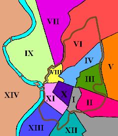
In 7 BCE, the emperor Augustus divided the city of Rome into fourteen administrative regions. VRoma uses these regions as a convenient way for you to enter different areas of our recreation of Rome circa 150 CE, during the reign of Antoninus Pius.
To begin your visit to Rome, you may click on the region of the map that you wish to explore or click on one of the exit names listed below. Please note that Region IX has been divided into three sections; click on the bottom of the region (or the Region 9 South exit) to visit the monuments in the southern section; click on the middle of the region (or the Region 9 Center exit) to visit the central part of the Campus Martius, and click on the top of the region (or the Region 9 North exit) to visit the monuments in the northern section. If you get lost while exploring on foot, you can always return to this map by using the Quick Jump bookmarks.
N.B. Region 1 leads to the Via Appia and hence to Pompeii.