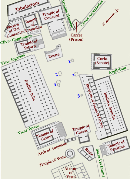
This map is a simplified version of the Forum Romanum, the heart of the City of Rome at its height, and the scene of many of its most dramatic political moments.This model presents the view of the Forum from the Sacra Via infima at the bottom of the map. Various authors refer to the bustle of activity that might take place here. Each of the monuments labeled here constitutes a separate place that you can visit by clicking on the map's "hotspots." If you get lost while exploring, you can always return to this map using the Quick Jump bookmarks.
The layout above represents features that were visible about 150 CE. Except for the absence of the Arch of Septimius Severus, which was not to be built for another half century, the diagram above corresponds more or less closely to the structures whose ruins are still visible. Reconstructed, this area would have looked something like this drawing. You can also see a larger reconstruction of the eastern end of the Forum (same view with labels) and the western end of the Forum (same view with labels). If you click on the blue numbers in the map, you will see information and pictures relating to other interesting features in the Forum: 1) Lapis Niger; 2) Area of the Fig, Olive, and Vine; 3) Shrine of Janus Quirinus/Geminus; 4) Lacus Curtius; 5) Shrine of Cloacina.
![]() To follow Tristia Tresunus to his final destination, climb the Clivus Argentarius.
To follow Tristia Tresunus to his final destination, climb the Clivus Argentarius.